
Download RouteBuddy – GPS Navigation, Mapping, and Route Planning for Mac
Overview
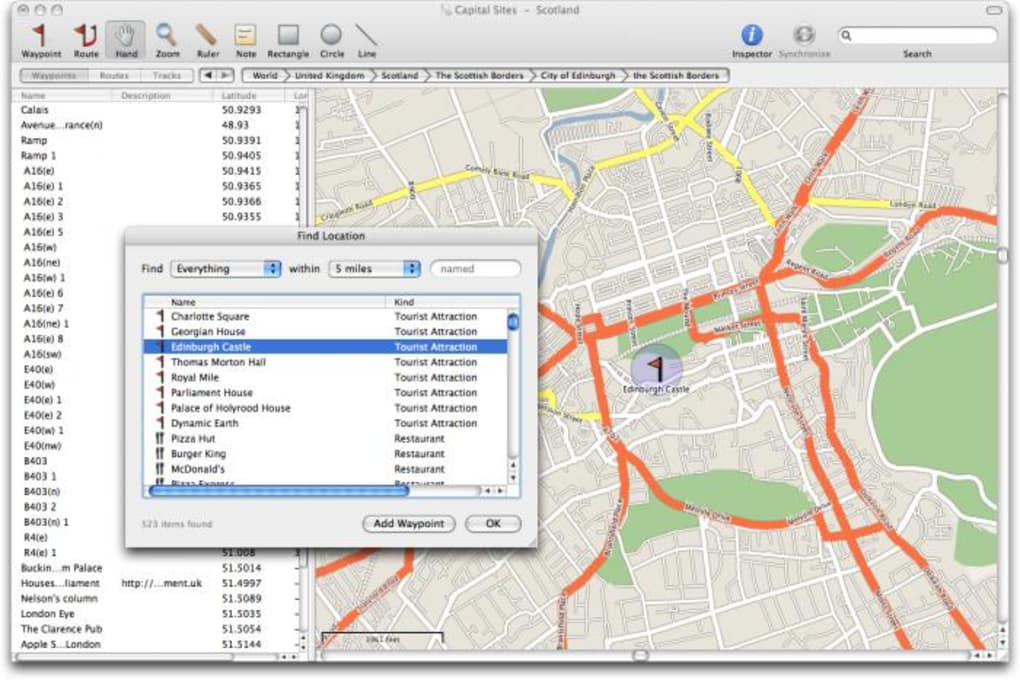
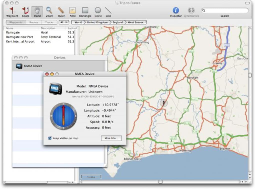
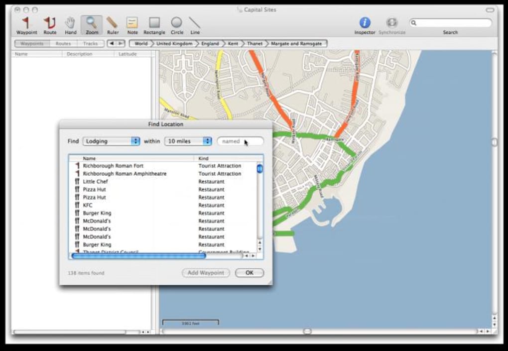
RouteBuddy is a powerful mapping and GPS‑navigation application designed exclusively for macOS. While many navigation tools simply give you turn‑by‑turn directions, RouteBuddy adds a suite of extra features that make long‑distance planning, off‑road adventures, and daily commuting more intuitive. Users can search any location worldwide, drop pins, attach notes, and even sketch lines or freehand drawings directly onto the map. This flexibility is ideal for travelers who need to mark points of interest such as hotels, restaurants, fuel stations, or scenic viewpoints along a complex itinerary. The software supports a broad range of GPS devices, allowing you to download routes to your hardware and monitor real‑time location without leaving the application.
One of the standout capabilities is the ability to replay an entire itinerary inside RouteBuddy. This playback feature lets you review the route, verify waypoints, and adjust the plan before hitting the road. The demo version offers a functional glimpse of the interface, but it places a semi‑transparent watermark over the map and disables map updates. To unlock the full experience—including the latest online map updates, offline map downloads, and removal of the watermark—you’ll need to purchase the full license.
Recent updates have added a topographical map layer for hikers and off‑road enthusiasts, improved import/export compatibility with GPX, KML, and Garmin RoadTrip files, and fixed several stability issues that previously caused crashes during tile rendering or when quitting the app during an import. These enhancements make RouteBuddy a reliable companion for anyone serious about preparing detailed journeys and keeping their GPS data accurate and up‑to‑date.
Key Features & Benefits
- Advanced Search & POI Finder: Locate hotels, restaurants, gas stations, and other points of interest near any waypoint.
- Annotation Tools: Add text notes, colour‑coded pins, and freehand sketches directly onto the map for personalized route markings.
- Multi‑Device Support: Seamlessly sync routes with a wide range of GPS receivers, including Garmin, TomTom, and other NMEA‑compatible units.
- Topographic & Satellite Layers: Switch between street, satellite, and topographic views to suit driving, hiking, or off‑road planning.
- Route Playback: Replay your entire itinerary inside the app to verify waypoint order, distances, and elevation changes before you depart.
- Live Map Updates: Access the latest road changes, new points of interest, and map corrections via an online update service (full version only).
- Import/Export Flexibility: Import GPX, KML, and CSV files; export routes in GPX for Garmin RoadTrip or other navigation platforms.
- Customizable Browser Columns: Rearrange columns in the route list to match your workflow, and preserve sort order across sessions.
- Offline Capability: Download maps for use in remote areas where internet connectivity is limited or unavailable.
- Secure Data Handling: All route data is stored locally on your Mac with optional encrypted backups to protect sensitive travel plans.
These features collectively transform RouteBuddy from a simple map viewer into a comprehensive travel‑planning studio. Whether you’re mapping a cross‑country road trip, plotting a weekend bike ride, or organizing a multi‑day trek through rugged terrain, the combination of searchable POIs, annotation tools, and robust import/export options means you spend less time juggling separate apps and more time fine‑tuning your adventure. The topographic layer, in particular, gives hikers and off‑road drivers the elevation context they need to avoid steep grades or identify suitable camp spots.
Security and reliability have also been a focus. Recent bug fixes eliminated crashes that occurred during tile rendering and when quitting the app mid‑import, ensuring a smoother experience on older Mac models. The ability to turn off demo maps and hide the watermark makes the paid version feel polished and ready for professional use, whether you’re a travel blogger, logistics manager, or weekend explorer.
Installation, Usage Instructions & Compatibility
Step‑by‑Step Installation
- Visit the official RouteBuddy website and click the Download for macOS button.
- Once the
.dmgfile finishes downloading, double‑click it to mount the installer. - Drag the RouteBuddy icon into your
Applicationsfolder. - Launch the app from
LaunchpadorFinder. macOS may ask you to confirm that you trust the developer; click Open. - If you have a GPS device connected via USB or Bluetooth, allow RouteBuddy to access the device when prompted.
- Register your license key (if you purchased the full version) under Preferences → License to unlock map updates and remove the demo watermark.
Getting Started with a New Route
After installation, the main dashboard presents a clean map view with a search bar at the top. Type any address, city, or landmark to jump directly to that location. Use the + Add Waypoint button to place pins along your planned path. For each waypoint you can:
- Enter a custom note (e.g., “Check in at 3 PM”).
- Select a colour‑coded icon to differentiate between hotels, fuel stops, and scenic viewpoints.
- Draw a freehand line or shape to highlight a particular area (useful for marking a detour or a campsite).
When you’re satisfied, click Export → GPX to save the route for use on your GPS unit. If you need to import an existing GPX or KML file, choose Import → File and follow the prompts. RouteBuddy will automatically align the imported points with its map layers and preserve any custom annotations where possible.
System Requirements & Operating System Support
RouteBuddy runs on macOS 10.14 (Mojave) and later, including macOS Ventura and macOS Sonoma. The application is optimized for both Intel‑based Macs and Apple Silicon (M1/M2) devices, taking advantage of native ARM performance when available. Minimum hardware specifications are:
- 2 GB RAM (4 GB recommended for large route files).
- 500 MB of free disk space for the application and temporary map caches.
- Internet connection for map updates and license activation.
Because RouteBuddy is a macOS‑only product, Windows, Linux, Android, and iOS users will need to rely on alternative solutions or run the app via a macOS virtual machine.
Once installed, RouteBuddy automatically checks for software updates each time you launch the program. Keeping the app up‑to‑date ensures you receive the latest map data, bug fixes, and new features such as additional topographic layers or expanded GPS device compatibility.
Pros, Cons, Frequently Asked Questions & Final Verdict
Pros
- Rich annotation tools let you personalize maps with notes and sketches.
- Supports a wide range of GPS devices, making synchronization straightforward.
- Topographic and satellite layers cater to both drivers and outdoor enthusiasts.
- Robust import/export options (GPX, KML, CSV) streamline data exchange.
- Stable performance after recent bug‑fixes, with native Apple Silicon support.
Cons
- Only available for macOS; Windows or mobile users must look elsewhere.
- The demo version’s watermark can be distracting during route planning.
- Full map updates require a paid license; no free offline map packs.
- Learning curve for advanced annotation features may be steep for beginners.
Frequently Asked Questions
Can I use RouteBuddy without an internet connection?
Yes. After downloading the desired map area, you can work completely offline. However, map updates and POI searches require an internet connection.
Which GPS receivers are compatible with RouteBuddy?
RouteBuddy supports most NMEA‑compatible devices, including Garmin, TomTom, Magellan, and many aftermarket receivers that use standard serial or Bluetooth connections.
How often are the online maps updated?
Map data is refreshed monthly for paid users. Free demo users receive the same baseline maps but cannot download the latest updates.
Is there a way to export my annotated maps as images?
Yes. Use the File → Export → Map as Image option to save a high‑resolution PNG or JPEG that includes all notes and drawings.
What is the refund policy if I’m not satisfied?
The developer offers a 30‑day money‑back guarantee for purchases made directly through the official website. Contact support with your order number for a full refund.
Conclusion & Call to Action
RouteBuddy stands out as a feature‑rich, macOS‑only navigation suite that caters to both casual drivers and serious expedition planners. Its blend of searchable points of interest, powerful annotation tools, and seamless GPS device integration provides a level of control that many mainstream navigation apps lack. While the lack of Windows or mobile versions and the presence of a watermark in the demo may deter some users, the overall value of the full version—especially for those who need topographic maps and offline capabilities—justifies the investment.
If you’re ready to take the guesswork out of route planning and want a Mac‑centric tool that lets you draw, annotate, and export routes with ease, download RouteBuddy today. The free demo lets you explore the interface, and the full license unlocks regular map updates, removes watermarks, and gives you the complete set of features for a secure, reliable navigation experience.